| The History of World Expositions |
|
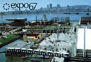
The Montreal World Exposition 1967
The world exhibition site was constructed near the harbor on two islands in the middle of the 1,700 meter wide St. Lawrence river, which flows through Montreal. The landscape architect Frederick G. Todd proposed retaining the island of Sainte-Hélène, which was used by the city's inhabitants as a natural recreation park, and extending it for the new buildings by means of filling. The new island of Notre-Dame was created south of it near the banks of the river. For months, sludge and silt were removed from the river and transported by lorry to the future exhibition site. A total of 1.2 million cubic meters of earth had to be moved to reclaim 120 hectares of new land. The third part of the exhibition site was formed by the Mackai Pier at the harbor, which was likewise extended and renamed City du Havre. The Habitat 67, an innovative urban housing project, administrative buildings, the stadium and the Expo Theater were erected on this peninsula. The islands were connected by bridges. In line with the varied structure of the site, the pavilions were divided into four groups, between which there were water or green areas. |
||||||||||||
|
EXPOSEEUM - The Museum of World Exhibitions, Hanover, Expo Plaza 11 Open every Sunday from 11 to 16 |
||||||||||||